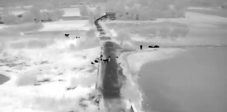
‘With the help of thermal imaging drone cameras, it has become easier to identify individuals and livestock trapped in floodwaters’

(Web Desk): For the first time in the country’s history, thermal imaging drone technology was successfully used to identify flood victims, enabling a successful rescue operation in remote and hard-to-reach areas.
In Jhang, including areas such as Semi Pull Bypass and Sargodha Road, drones were used to locate individuals and livestock trapped in the floodwaters.
During the operation, thermal imaging cameras detected five individuals and livestock surrounded by water. Their location was traced, and the rescue team immediately reached the flood-affected area.
The rescue team safely relocated all five individuals and the livestock to a secure location.
Similarly, in the river belt of Chishtian, the process of locating flood victims using drone cameras is ongoing.
In the flood-affected areas of the river belt in Bahawalnagar as well, thermal imaging drones are being deployed.
With the help of thermal imaging drone cameras, it has become easier to identify individuals and livestock trapped in floodwaters.

Why the right is freaking out about “third worldism”
- ایک دن قبل

Arshad Nadeem reaches Commonwealth Javelin final
- 15 گھنٹے قبل

New Yorkers will soon need to verify their age to access algorithmic feeds
- ایک دن قبل

Is it illegal to trick the US government into wiping your phone during a questionably legal search?
- 4 گھنٹے قبل

SSWMB sackings trigger fairness concerns, Karachi mayor urged to intervene
- 18 گھنٹے قبل

AI could end up too cheap to control
- 2 گھنٹے قبل

eBay’s bizarre cyberstalking saga ends with a $56 million settlement
- ایک دن قبل

The union drive at the Wikimedia Foundation is expanding
- ایک دن قبل

Why Europe is warming twice as fast as the global average
- ایک دن قبل

The Covid debate that never ended
- 2 گھنٹے قبل

Why it took so long to talk about perimenopause
- ایک دن قبل

Jordan's army says shot down 5 Iranian missiles
- 16 گھنٹے قبل


